


The project involves a pilot experience to find suitable formulas to slow down, as much as possible, the process of environmental degradation taking place in the Maspalomas dune complex during the last 50 years, to avoid the disappearance of the mobile dune area and preserve its environmental value and importance as a tourist attraction. The most important erosion factors in the dune system are storms and the alterations derived from climate change. Furthermore, the dunes are under constant threat since the natural wind systems have undergone important anthropic alterations, as a consequence of the urban development of the last years. Given that the Maspalomas dune system constitutes an environment of special scientific interest as well as a Nature Reserve and a Special Conservation Area, the Canary Islands Government (Cabildo de Gran Canaria) has deployed a series of protection and conservation measures in this regard, developed through the Masdunas pilot experience.
The dunes of the Maspalomas Reserve are formed by sediments from the erosion of volcanic rocks and the decomposition of marine organisms (foraminifera, calcareous algae, ...). Marine currents deposit these sediments on the shore which, once dried, are pushed inland by the wind where afterward, plants like the balancones, a type of halophyte shrub (Traganum moquinii), favor their progressive accumulation. Another part of the sand surrounds the balancones and is deposited behind them, forming small leeward dunes that come together forming dunes that move inland, called Barkhan dunes. The union of several Barkhan dunes forms more complex dunes called barkhanoid ridges, which are the main type that makes up the mobile dunes of Maspalomas. There is no mention of dunes in Maspalomas in any of the historical chronicles before approximately 1800, and are thought to have originated in 1755 as a direct consequence of an Atlantic tsunami that probably altered the seabed in Maspalomas and accumulated the sand that today forms the dunes and the ecosystem of La Charca de Maspalomas. Until the 1960s, when strong tourism began, the dunes maintained a natural state, surrounded by agricultural wheat and tomato fields, harboring ducks, terns and large numbers of migratory birds that reproduced on them. Environmental degradation suffered since, both in the Natural Reserve area and in its immediate surroundings as a consequence of the great urban-tourist development that has altered the natural wind systems in the area, among other factors, is now favored and enhanced by the effects of climate change (increased coastal erosion and flooding, rising sea levels, ...).
Given these conditions, the fundamental challenges facing the MASDUNAS project are:
- filling the knowledge gap on the environmental restoration of arid coastal dunes
- boosting protection and conservation management of the natural spaces of the Masdunas Special Natural Reserve
- establishing measures to prevent sand loss and improve the environmental quality of the dune system
- conducting field interventions in an area intensively subject to tourism throughout the year improving the little existing experience in the management of metaprojects (a set of projects which, making sense on their own, provide positive synergies when executed in coordination)
- improving communication among administratins, public and private entities, and social and scientific agents, promoting coordinated networking and the transfer of experiences and knowledge.
The climate change emergency, evidenced by more frequent occurrences of extreme events such as coastal floods, together with several human activities linked to tourist-urban uses, will irreversibly erode and degrade the dune system of Maspalomas and its Nature Reserve if no action is taken accordingly.
In this sense, the environmental problems affecting the Maspalomas dunes are fourfold:
sedimentary erosion produced by the alteration caused by the wind flow, which causes the loss of sand to the sea along with an increase in the vegetation cover in inland areas, a decrease in the areas occupied by dunes and an increase in eroded areas (deflation surfaces)
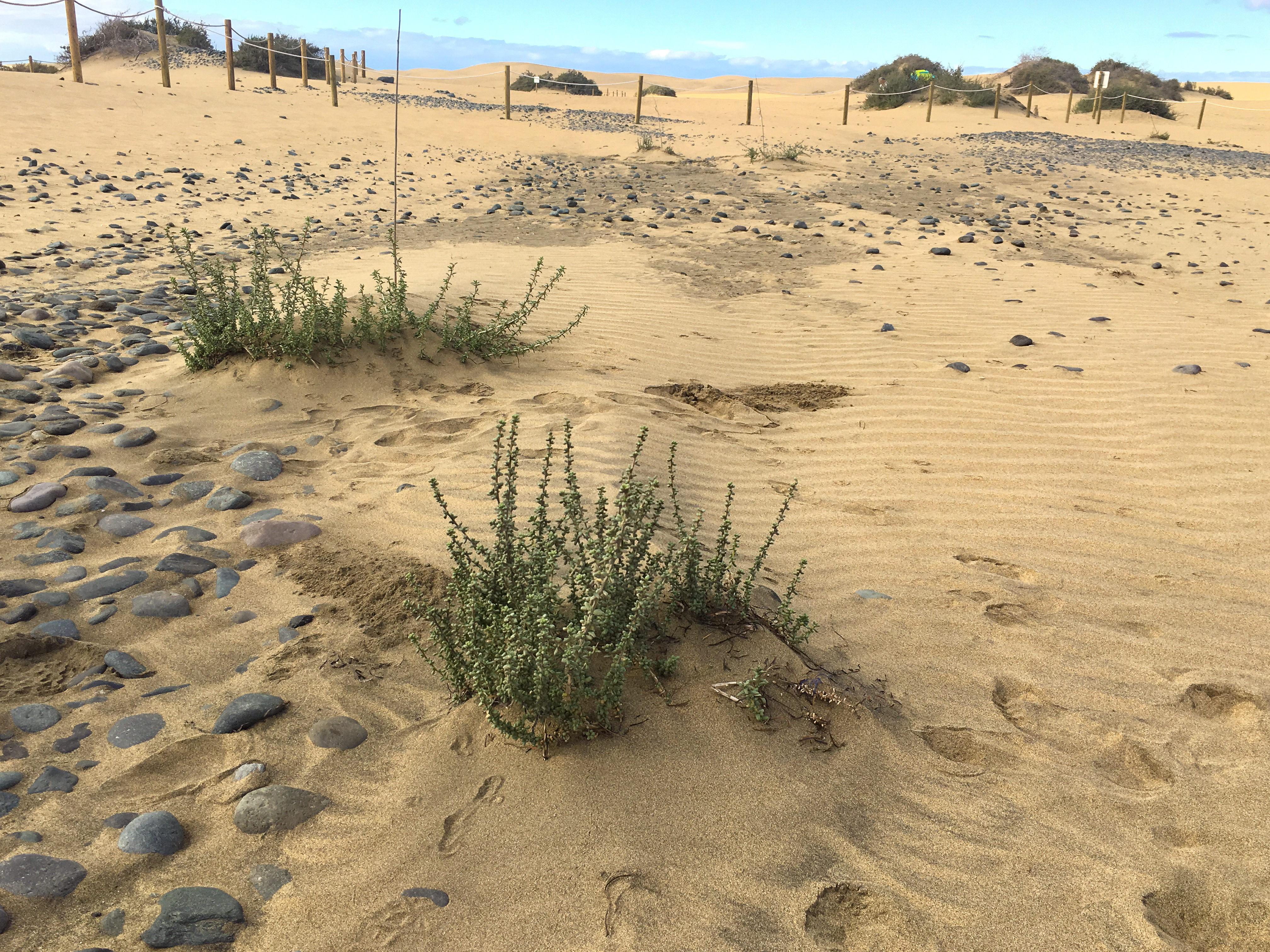
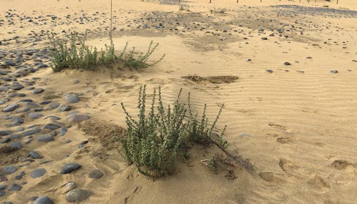
loss of balancones (Traganum moquinii), which regulate the transport of sand and favor the formation of the Barkhan dunes and barkhanoid ridges, which are characteristic of this mobile dune system
loss of biodiversity, as a consequence of the above and of the intense and disorderly public use in the area along with the presence of invasive exotic species, which produce alterations in the functioning of the ecosystem and the loss of its natural heritage
alteration of the landscape and public use with the opening of new trails, trampling over vegetation, alteration of dune dynamics, abandoned litter, etc., which generate negative impacts on biota and the local territory
Faced with this problem, the objectives pursued by MASDUNAS are:
establish a model to stop the sedimentary erosion of the organogenic sands on the beaches of Maspalomas, El Inglés and the Special Natural Reserve of the Dunes of Maspalomas
protect the current populations of balancones (Traganum moquinii) by fencing off the area and signposting
restock with balancones as dune formation elements
control invasive plant and animal species in the Nature Reserve
eliminate windbreak shelters (low stone walls) made of plant material or stones left by users in the area
mark and signal the official trails of the Nature Reserve
control and eradicate illegal buildings in the area
properly communicate the actions to the population
Given the situations and scenarios described, the Department of Environment of the Cabildo de Gran Canaria had three options:
refrain from intervening in any way, and let the ecosystem continue to degrade
close the beaches and the Nature Reserve completely to the public
proceed to the environmental rehabilitation of the dune system and the Nature Reserve
The first of the options was discarded since the Department has a legal mandate for managing said ecosystem, both as a Nature Reserve and a Special Conservation Area (Natura 2000).
On the other hand, this ecosystem is the base of a powerful tourist industry that has been operating year-round for half a century. This means that it is an important niche for employment (social effect) and wealth (economic effect), which led us to discard the second of the alternatives, that of closing the beach and the Reserve, since these benefits would cease, aside from the administrative social and political problems that would be generated.
In any of the previous cases, the relief to the degradation process would very limited and would not provide solutions to the loss of sand.
Finally, the third option was chosen, that of proceeding with environmental rehabilitation through the drafting, agreement, processing, financing and execution of the MASDUNAS project.
The actions thus projected focus mainly on two fundamental aspects:
1. Stop the sand loss process of the dune system, by:
a. restocking of sand from Punta de la Bajeta to Playa del Inglés, contributing more than 60,000 m3 of sand from dredging in an emerged area of Punta de la Bajeta, with setback up to a maximum defined by the 1995 beach profile. The extracted sand is relocated to the dry beach area of Playa del Inglés, so that it is transported naturally by the wind to the coastal dune, characterized by the presence of balancones halophyte shrub pecimens (Traganum moquinii).
b. installing sand collectors with a design adapted to arid conditions and reintroduction of balancones specimens to favor the formation of dunes and regulate the advance of the sand towards the interior. Planting loose balancones specimens as well as associated plant types with different models of sand catchers in different plots of the Playa del Inglés beach, in order to objectively determine the best and most efficient solution for the environmental restoration of the dunes of Maspalomas
c. scientific monitoring to ensure the correct assessment of the measures implemented; evolution of the restocked sand and evaluation of the capacity of the different sand collectors and the balancones to create dunes and regulate the transport of sand inland
2. Improve the environmental quality of the dune system in order to recover its biodiversity and improve the management of the Reserve's public use, including the following actions:
a. restocking of balancones, introducing specimens obtained from germination or cuttings both from the northern area of Playa del Inglés and in the interdune troughs of Cañada de la Penca. The balancones stands are fenced off to prevent trampling and are watered during the first 9 months.
b.improvements in biodiversity, reducing the presence of exotic species, mainly plants, that are displacing the native biota. Improvements in floristic biodiversity consist of the elimination of species by means of approved methods that avoid their dispersion and possible sprouting, acting fundamentally on:
crimson fountaingrass (Pennisetum setaceum)
castor bean (Ricinus communis)
sweet acacia (Acacia farnesiana)
prickly pear (Opuntia dillenii)
tree tobacco (Nicotiana glauca)
short-leaf bush (Maireana brevifolia)
shoreline purslane (Sesuvium portulacastrum)
broadleaved pepper tree (Schinus terebenthifolius)
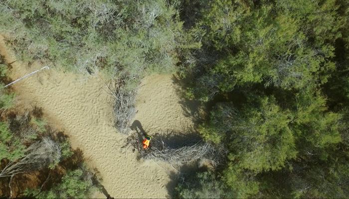
c.elimination of wooden and rock shelters located in the Reserve, both in the restricted use zone and in the exclusion zone. Since these shelters are usually built with dry branches extracted from the shrubs (Tamarix canariensis) of the Reserve, they represent, in addition to a distorting element of the landscape, a serious risk of fire.
d.Re-signaling/marking of trails – combining a responsible public use of the system with its conservation – acting on the 8 km of trails that pass through the Reserve, with more than 1,500 vertical bollards and information signs, especially around the exclusion zone to avoid deterioration of the site due to lack of knowledge of the rules.
In any case, in addition to these actions, it is necessary to raise awareness among the population and users about the Reserve and neighboring beaches to raise awarenss on the serious disturbance caused due to failure to observe the rules of use of the different zones in such a fragile ecosystem area, so as to avoid environmental degradation and to preserve and improve the dune system and the Maspalomas Nature Reserve.
Several environments can be distinguished In the Maspalomas Nature Reserve depending on the mobility of the sand, the vegetation cover and the type of substrate.
Furthermore, the location of the Maspalomas dunes on an alluvial fan is of great ecological importance, since it evidences the presence of groundwater at a shallow depth. This provides for the existence of more demanding plant species in terms of water availability, such as shrubs (Tamarix canariensis) and reeds (Juncus acutus), which are generally not common in dune fields. In turn, around the Reserve the dunes continue in the adjacent underwater platforms.
All this makes this area a natural system of great singularity and a unique one in the archipelago, whose conservation and protection is of fundamental interest.
The Maspalomas dune system is highly exposed to the risks derived from climate change, in particular due to the increase in high temperatures and the scarcity of rains, which favor the mobility of the sand, which in turn favors the settlement of vegetation and the loss of sand.
In addition, the foreseeable rise in sea level, the alteration of the wind regime, and changes in the intensity and frequency of marine storms increase the vulnerability of these sand dunes to the effects of climate change.
For this reason, and in the current context of climate change, the conservation of the Maspalomas dune system is essential, as a measure of adaptation to achieve conservation of the Reserve's ecosystem, its recreational use and the tourist interest and use in the area.
Moreover, in addition to solving the challenges exposed, the development of a project like MASDUNAS can be an inspiring initiative experience for other areas, especially those with arid dunes.
Before its inception, the project was submitted to the consideration of the Governing Board of the Natural Reserve and the corresponding enabling documents were required by the different Public Administrations (Government of Spain, Government of the Canary Islands, City Council and other Councils of the Island Council, etc.) .
Prior to its kick-off, the project was also exhibited in professional forums such as Esparc (Congress of Europarc Spain).
During its execution, a preplanned communication and participation program within the project itself was activated. This has been substantiated through a website, a YouTube channel, multiple talks, guided tours, technical conferences, explanatory videos, press releases, interviews on social media, printed material, etc.
A highly effective collaboration has also been established between the Cabildo de Gran Canaria, the entity leading the project, the Canary Islands Coastal Demarcation and the San Bartolomé de Tirajana City Council.
Several MASDUNAS Conferences will be held during the development of the project, where, in addition to reporting on the results obtained and conducting visits to the works, participatory workshops will be held to provide the different social sectors an opportunity to voice their inputs and feedback, with a possible re-edition of the project for the 2020-2021 biennium.
MASDUNAS is a benchmark pilot undertaking, since no proposal of this nature exists elsewhere in the world, involving a project in a dune system like the one being carried out in Maspalomas, which, mainly due to the arid conditions in which its dunes develop, has different characteristics as opposed to other coastal dunes typical of temperate and tropical environments.
The intervention is carried out in a Natural Reserve area characterized by four different types of environments:
mobile dunes zone, which occupies the area extending from Playa del Inglés to Maspalomas, formed by interdune troughs and transgressive free and/or dunes covered with balancones, which advance towards the interior of the system moved by the NE-E trade winds.
interdune troughs can be humid, due to the existence of shallow groundwater, or dry, not influenced by the water table. These troughs are essential for plants, as this is where the plant colonization of the mobile dunes begins.
semi-stabilized dune zone, which extends through the central part of the system as a transition zone between mobile dunes and stabilized dunes, where the mobility of the sand is significantly reduced even when it is still present.The development of vegetation in this area begins to be more important, occupying an area larger than the mobile dunes
stabilized dune area, further away from the marine influence, where mobility is lost due to the lack of contributions of sand caused by the barrier effect of the sedimentary terrace and the urban buildings in Playa del Inglés.The vegetation cover covers practically all of the stabilized dunes
ravine and La Charca de Maspalomas, where the existence of a coastal lagoon that constitutes the most important wetland in Gran Canaria stands out and whose variable surface depends on the climatic regime.
The Maspalomas dune system shows a sedimentary cycle where the wind and the sea play a fundamental role. The sand enters the system through Playa del Inglés, where the trade winds from the NE pushes it inland. Once free dunes have formed, they advance in the E-W and NE-SW direction until they reach the sea along Maspalomas beach. However, when SW storms occur, the Maspalomas beach erodes, and part of the sand is deposited in Punta de la Bajeta. A part of these sediments is re-incorporated into this sedimentary cycle, while another part falls to a depth that prevents it from re-entering said cycle, causing the loss of a large volume of sand and acting as a natural "sink". This will not happen thanks to the launching of this ambitious project that involves constant monitoring to understand the response to each action.
In these conditions, MASDUNAS is a unique project characterized by three main points of interest:
its pilot nature, as an experience and action protocol in arid coastal dune areas
its execution within the area open to the public, carrying out the works in times of low influx of tourists and with contributions of sand taking place at night
the project implies an intervention in a full geological process involving a sedimentary cycle, in order to reduce the loss of sand in the configuration of the dune system towards the sea
the project provides an ecosystemic view of the problem (geology, vegetation, wildlife, habitats, public use, inter-administrative collaboration, communication, public participation, ...)
The actions carried out by MASDUNAS are yielding extraordinary results to date; the project therefore, is expected to continue.
In this sense, the following successes can be pointed out:
a work protocol is being defined to stop sedimentary erosion (types, arrangement and density of sand catchers, type and arrangement of vegetation; dates, volumes and method for sand movement). These tasks are accompanied by 16 LiDAR flights and powerful monitoring on land and in the adjacent marine EEZ, which will generate abundant scientific literature.
restocking of a large mass of lost sand
improvement of the biota of the area due to the removal of invasive species
improvement of the public use of the area through marking and signposting of the 8 km stretch of official trails
fencing off of balancones stands
14 photogrammetric flights have been made to date along with their rendering using digital elevation models
development of the entire scientific monitoring program
multiple communications and/or participation initiatives
Among the benefits that are being obtained through the actions undertaken, the following should be highlighted:
rehabilitation of the natural heritage of the area
qualification as a singular tourist destination
strengthening of ties and collaboration between the different Administrations involved
intensification of environmental awareness, especially regarding the conservation of the coastal dune ecosystem
The total amount of the project is € 1,155,018.33, and, although its initial financing came from the Cabildo de Gran Canaria, it is currently also co-financed by the FDCAN (Canary Islands Development Fund).
Expenses are structured as follows:
Construction work of the sand restocking pilot experience from Punta de la Bajeta and Playa del Inglés: € 553,819.52.
Scientific monitoring of sand movements: € 261,116.00.
Actions geared at biodiversity and public use: € 277,577.65.
Communication Plan: € 62,505.16.
The project is executed on the basis of the legal competencies of this Island Council with respect to the management of protected natural areas and, more specifically, the Special Natural Reserve of the Dunes of Maspalomas. Due to the ecosystemic approach, action has been taken throughout the dune system beyond the administrative limits of the protected space.
The project has all the pertinent permits and authorizations.
Prior to its drafting, all the current regulations that apply to the project were reviewed and assessed, such as the Law on Natural Heritage and Biodiversity, the Canary Islands Land Law, the Insular Plan for the Organization of the Territory of Gran Canaria, the Master Plan of the Nature Reserve, the Special Conservation Area Management Plan, the Coastal Law and the Impacts legislation.
The project’s gestation period spanned several years, but the executive phase began in July 2018 and ends in December 2019, resulting in a duration of 18 months. However, and as indicated earlier, a possible reissuance or expansion thereof is expected for the biennium 2020-2021.
https://masdunas.es/
Alcántara-Carrió J.; Fontán A.; Cólliga L.; Álvarez J.A.; Poveda J.M.; Peña M.A. 2007. Determinación geofísica del espesor de arenas en la Reserva dunar de Maspalomas (Sur de Gran Canaria, Islas Canarias). Resúmenes XII Runión Nacional de Cuaternario. Ávila. pp: 71-72.
Alonso I.; Montesdeoca I.; Vivares A.; Alcántara-Carrió J. 2001. Aproximación a la Modelización de la dinámica Litoral de las Playas de El Inglés y Maspalomas (Gran Canaria), 18: 17-27.
Alonso I.; Hernández L.; Mangas J.; Medina R. 2008. Sedimentología, hidrología y geomorfología del Campo dunar de Maspalomas. En: “Itinerarios Geológicos por las Islas Canarias”. Pérez Torrado F.J. & Cabrera M.C. (eds.). Sociedad Geológica de España. Geo‐Guías, 5: 121‐136.
Alonso I.; Montesdeoca I.; Vivares A.; Alcántara-Carrió J. 2001. Variabilidad granulométrica y de la línea de costa en las playas de El Ingles y Maspalomas. Geotemas, 1(3): 39-42.
Fontán A.; J. Alcántara-Carrió J.; Poveda M.; Peña M.A. 2007. Aplicación de técnicas de GPS diferencial, fotogrametría y geofísica a la cuantificación de procesos erosivos y balances sedimentarios en playas y dunas costeras. Actas del XII Congreso de la Asoc.. Esp. de Teledetección. Mar del Plata – Argentina. 4 pp.
Fontán A.; Alcantara-Carrió J.; Barranco A.; Rey J.; Pacheco A.; Montoya I.; Rey J.; Peña
Miguel Angel Peña Estévez
Consejería de Medio Ambiente del Cabildo de Gran Canaria
Coordinador General del proyecto MASDUNAS
Director Conservador de la Reserva Natural
Correo electrónico: mapena@grancanaria.com
Teléfono: 928 219 470 - Ext. 44115